 klaus-michael schneider
Keywords: bolivar | morales |
Links: FOTW homepage | search | disclaimer and copyright | write us | mirrors

FOTW beschäftigt sich mit der Wissenschaft der Vexillologie (Flaggenkunde).
Alle auf dieser Website dargebotenen Abbildungen dienen ausschließlich der Informationsvermittlung im Sinne der Flaggenkunde.
Wir distanziert uns ausdrücklich von allen hierauf dargestellten Symbolen verfassungsfeindlicher Organisationen.
Last modified: 2021-08-26 by  klaus-michael schneider
Keywords: bolivar | morales |
Links: FOTW homepage |
search |
disclaimer and copyright |
write us |
mirrors

image resized from municipal
web site
See also:
Morales is a municipality located in the Bolívar Department.
It was founded on 14 September 1610 by Don Pedro Vicente de
Morales.
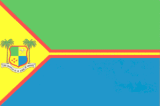
The flag of Morales is shown in the municipal
web site.
Source: municipal
web site.
Dov Gutterman, 1 September 2008
Translated from municipal
web site:
"The flag of the municipality of Morales is of dimension 1.5
m x 1 m. It is made of two main stripes placed horizontally,
green and blue, representing, like on the shield, the two
contrasted geographic regions forming the municipal territory: a
higher, montainous region [green] and a lower region including a
network of marshes and banks [blue]. A yellow isosceles triangle
is placed along the hoist, charged with the municipal shield.
From the triangle emerges a thin yellow stripe with a red
fimbriation separating the two horizontal stripes from each other
and from the triangle sides. Yellow represents the gold
resources and the promising future of this glorious
region, while red is a posthumous tribute to the nobleness and
heroism of our countrymen who fought in the so-called Battle of
the Bishops." "The shield is a simple Polish shape, 6 x
6, quartered. The first quarter, green, represents the splendor
of the higher, mountainous region and the fertility of its soil.
The second quarter, yellow, is charged with the elements
characteristic of mining [a shovel and a peak crossed per saltire
and surmonted by a helmet, all white], as the maximal expression
of our resources. The third quarter, yellow, is charged with four
red stars placed in each of the four main compass directions,
representing kindness to our visitors and the four historical
territories merged to form the municipality, Morales, Río Viejo,
Regidor and Arenal. The fourth quarter, blue, represents the
lower, marshy region and its water resources.
The shield is flanked by two palm trees, recalling the founding
name of the place, "San Sebastián de las Palmas de
Morales", which is also written in black letters on a silver
wavy scroll from which the palm trees emerge."
The image of the shield shown on the municipal website points to
a high-resolution
image.
Gold mining takes place in the "corregimiento" of Mina
Gallo, located in the massif of San Lucas. Neighbouring the
municipality of Santa Rosa del Sur, this region is characterized
by a high level of violence. Therefore, there is little control
of gold mining and the local water resources, such as the sources
of Arenal and Honda are highly contaminated with pollutants such
as mercury cyanide.
Ivan Sache, 7 September 2008
bolms.jpg)
image from municipal
web site
Hosted by: Fanshop-Online.de und Handy-Shop.de
Tipp: Apple iPhone 12 im Shop