 zachary harden
Keywords: hungary | pest | budapest |
Links: FOTW homepage | search | disclaimer and copyright | write us | mirrors

FOTW beschäftigt sich mit der Wissenschaft der Vexillologie (Flaggenkunde).
Alle auf dieser Website dargebotenen Abbildungen dienen ausschließlich der Informationsvermittlung im Sinne der Flaggenkunde.
Wir distanziert uns ausdrücklich von allen hierauf dargestellten Symbolen verfassungsfeindlicher Organisationen.
Last modified: 2023-06-03 by  zachary harden
Keywords: hungary | pest | budapest |
Links: FOTW homepage |
search |
disclaimer and copyright |
write us |
mirrors

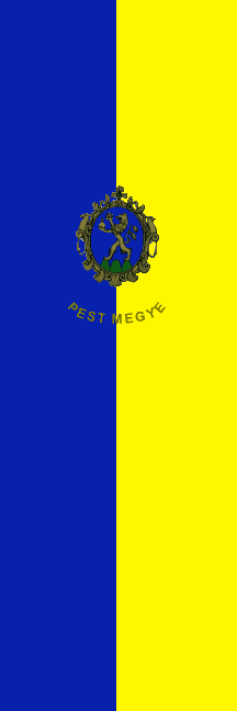
image by Zoltan Horvath, 2 March 2001
See also:
Municipalities (187 settlements, including 47 towns and 1 city):
City (not part of the county):
Towns:
Other municipalities in FOTW:
Other sites:
The flag is bicolour with Coat of Arma and above the Coat of
Arms is the name in gold letters: PEST MEGYE. The colours are:
blue and yellow (gold). In a third is the Coat of
Arms. There are a horizontal and a vertical version.
Two picture of desk flags are in the official site of the county:
<www.pestmegye.hu>.
István Molnár, 19 October 2000
Concering Zoltan Horvath image above - the blue is
darker as in the Coat of Arms.
István Molnár, 2 March 2001

image by Istvan Molnar, 27 August 2001
Flying flag at the Conquest Statue, Opusztaszer NHP. Ratio:
3:1. The width of the Coat of Arms is the 1/3 of the width of the
flag. The Coat of Arms is on the 1/3 of the flag's height. The
inscription is gold.
Istvan Molnar, 27 August 2001
pe.gif)
image from <www.pestmegye.hu>,
located by Istvan Molnar, 13 July 2000
Pest megye (megye=county) is located on the heart of the
contry around Budapest capital. Neighbouring counties are:
Komárom-Esztergom megye, Fejér megye, Bács-Kiskun megye,
Jász-Nagykun-Szolnok megye, Heves megye, Nógrád megye,
Nitriansky kraj (Slovak Rep.) and Budapest capital. The territory
is 6.394 km2. The county (without Budapest Capital) has got
950,000 inhabitants, nearly all of them Hungarian. In the county
there are: 27 towns, 36 "large villages" and 121
villages. Ten of the Official EthnicMinorities of Hungary has got
ethnic councils in the county. They are: Bulgarian (in 3
settlements), Gipsy (in 45 settlements), Greek (in 1 settlement),
Croatian (in 3 settlements), Polish (in 1 settlement), German (in
32 settlements), Armenian (in 2 settlements), Ruthenian (in 1
settlement), Serbian (in 9 settlement) and Slovakian (in 12
settlements).
The territory of the county is inhabited from the Stone Age were
later explored by archeologist. The territory has rich
collections of the objects made by Scythians, Celts, Romans,
Sarmatians, Huns, Lombards and other German tribes.
During the reign of King Saint Stephen were formed two counties
of Pest and Pilis, later unifieed and destined to become the
political, cultural and economical centre of the country. After
the Mongol invasion of 1241, Visegrád, later Buda was became the
capital of Hungary. The local government of the county was
established in the late 13th c., and it has more or less
continuous ever since, apart form certain gaps explained by the
vicissitudes of Hungarian history. After 1541 the whole county
was occupied by the Turks. 74 out of its 214 prosperoues
communities became totally depopulated. The territory was
liberated in 1686. The Pest-Pilis County was united with Solt
County (part of Fejér County in the left bank of the Danube). In
the 18th century Pest County found itself again, with economy and
the number of inhabitants on the increase. It was during this
period when ancestors of the minorities living here made the
county their home. Free Royal City of Pest, Free Royal City of
Buda, Town of Óbuda and the Margaret Island were unified in 1872
under the name of Budapest - with Town of Óbuda and Margaret
Island "torn from their parent, Pest County. In 1876
Pest-Pilis-Solt County was united with the territories of
Kiskunság (Little Cumania) and the new county have got the name:
Pest-Pilis-Solt és Kiskun Törvényesen Egyesült Vármegye
(Pest-Pilis-Solt and Kiskun Legally United County).
The Coat of Arms the Pest-Pilis-Solt-Kiskun County (1876-1950)
can be seen at <www.fortunecity.com>.
After theWWII (1946) the borders of the county was changed
drastically. In 1950 the territory of the county had been diveded
into two parts. The southern part (Dunavecse district, Kalocsa
district, Kiskőrös district, Kiskunfélegyháza district,
Kunszentmiklós district, Lajosmizse, Ladánybene and Újbarcs
villages, Town of Kalocsa, Town of Kiskunfélegyháza, Town of
Kiskunhalasand the City of Kecskemét) united with Bács-Bodrog
County (now Bács-Kiskun County). The northern part got new name:
Pest County. Seven towns (Budafok, Csepel, Kispest,
Pesterzsébet, Pestlőrinc, Rákospalota, Újpest) and 16
villages were united to Budapest.
Istvan Molnar, 13 July 2000
Hosted by: Fanshop-Online.de und Handy-Shop.de
Tipp: Apple iPhone 15 im Shop