Fahnen, Flaggen und Kalender bei Fanshop-Online.de bestellen
This page is part of © FOTW Flags Of The World website.FOTW beschäftigt sich mit der Wissenschaft der Vexillologie (Flaggenkunde).
Alle auf dieser Website dargebotenen Abbildungen dienen ausschließlich der Informationsvermittlung im Sinne der Flaggenkunde.
Wir distanziert uns ausdrücklich von allen hierauf dargestellten Symbolen verfassungsfeindlicher Organisationen.
Vaals (The Netherlands)
Limburg province
Last modified: 2018-12-15 by rob raeside
Keywords: vaals |
Links: FOTW homepage |
search |
disclaimer and copyright |
write us |
mirrors
 Shipmate Flagchart : http://www.flagchart.net
adopted 11 Mar 1963
See also:
Vaals municipality
Population (1 Jan 2003): 10.621; area: 23,90 km². Settlements: Vaals
(seat), Camerig, Cottessen, Harles, Holset, Lemiers, Mamelis, Melleschet,
Oud Lemiers, Raren, Rott, Vijlen, Wolfhaag. Vaals is mostly known for the
"Drielandenpunt" (threecountriespoint), where the borders of the
Netherlands, Belgium, and Germany meet. It is at the same time the highest
point in the Netherlands: 322,5 m above sealevel. This used to be a "Vierlandenpunt"
(four countries), when Moresnet (Belgium) was
a neutral exclave. See Kelmis (Belgium).
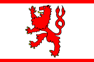
Flag: adopted 11 Mar 1963 by municipal resolution. Description: rectangular
white, with in the center a red lion armed yellow; on top and bottom a
narrow horizonal red stripe.
Visser reports a square banner.
Source: the Vaals municipal webpage.
Derkwillem
Visser's "Gemeentewapens en Vlaggen Koninkrijk der Nederlanden:, 2001.
Historical flag
 Shipmate Flagchart : http://www.flagchart.net
Hosted by: Fanshop-Online.de und Handy-Shop.de
Tipp: Apple iPhone 12 im Shop
 Shipmate Flagchart : http://www.flagchart.net

 Shipmate Flagchart : http://www.flagchart.net
 Shipmate Flagchart : http://www.flagchart.net