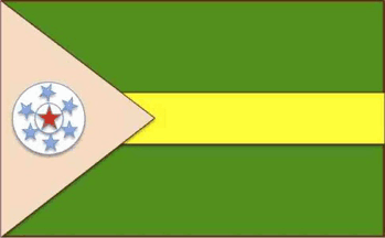
arl.jpg) images by Valentin Poposki and Bruce Berry, 13 June 2021
images by Valentin Poposki and Bruce Berry, 13 June 2021
FOTW beschäftigt sich mit der Wissenschaft der Vexillologie (Flaggenkunde).
Alle auf dieser Website dargebotenen Abbildungen dienen ausschließlich der Informationsvermittlung im Sinne der Flaggenkunde.
Wir distanziert uns ausdrücklich von allen hierauf dargestellten Symbolen verfassungsfeindlicher Organisationen.
Last modified: 2023-02-03 by bruce berry
Keywords: somalia |
Links: FOTW homepage |
search |
disclaimer and copyright |
write us |
mirrors
The complete list of Quasi-independent and semi-autonomous regions in Somalia can be found here. Areas beginning with letters H - Q can be found here and with letters R - Z can be found here.

arl.jpg) images by Valentin Poposki and Bruce Berry, 13 June 2021
images by Valentin Poposki and Bruce Berry, 13 June 2021
 image by Eugene Ipavec, 19
Sep, 2010
Awdal is clan based division based on a 16th century sultanate in the
westernmost region between Somaliland and
Djibouti inhabited by Gadabursi sub-clan of the Dir.
Somaliland and Adwalland are vying for control of this region. Awdal State of
Somalia wants to be part of a federal government of Somalia. Its second
anniversary took place in Switzerland on 20 March 2012. The closest that
Rashid Aw Nor Hirsi, the president of Awdal State of Somalia, can travel is
Mogadishu and the areas where Somaliland army have no presence.
Cai Zhenyuan,16 July 2013
It is not clear if Awdal is another self-proclaimed state or semi-autonomous region. The proposed flag of Awdal (see above) can be seen on many websites and variant can be seen in a photo on Somali.net (see below), which probably means it has been adopted.
 image by Eugene Ipavec, 19 Sep, 2010
Valentin Poposki, 16 Sep 2010
When Somaliland proclaimed its independence in
1991, it was opposed by the west province (populated by the Dir sub-clan
Gadabursi) and proclaimed the Awdal republic. Borama is the main commercial
centre. An agreement was signed with with the Somaliland Government of Hargheisa
but this was not adopted any enthusiasm.
The flag initially used was white with the region's Arms in the center according
Jim Davidson, the Chief Financial Officer of the Awdal Roads Company. However,
this flag was no longer being used by the end of the 1990s.
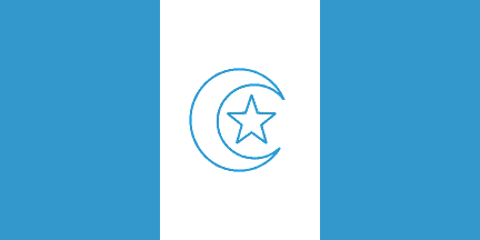 image by Peter Hans van den
Muijzenberg, 17 April 2015
In 2009 the local authorities proclaimed a new Awdal state opposed to
Somaliland, with little control of the rest of the province. The flag adopted
had three vertical stripes of light blue, white and light blue (in
Canadian
pale), as shown above in two versions. It appears that there is also a third
version which has equal vertical bands.
Jaume Ollé, 02 October 2014
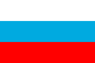 image by Cai Zhenyuan, 28 Dec 2011
Azania was established on 20 March 2011 in Kenya and is supported by Kenya,
which is interested helping develop a regional administration and establish a
buffer zone against threats from al-Shabaab. Azania state is led by Mohamed Abdi
Gandhi, a former Somalia defence minister. He is an educated man who has
personal contacts with the governments of both Ethiopia and Kenya. The regional
state works in Gedo and Lower Jubba regions, and its capital is Bu'aale town.
Cai Zhenyuan, 16 July 2013
After seven days of deliberations in April 2011, Somalia’s Transitional Federal
Government, members of parliament, civil society groups and clan elders agreed
to the formation of a semi-autonomous state to be called Azaaniya.
Originally known as Jubaland, Azaaniya comprises lower
and middle Juba and Gedo regions on the Kenya-Somalia
border. On 03 April 2011, Prof Muhamed Gandhi Mohamed was sworn in as the
interim
president of the newly-created state.
http://jubbalandnews.com
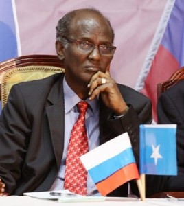
It was further reported that the flag of
Azania shall be rectangular in shape with three colours - red at the bottom,
White at the top and blue in the middle, with all stripes being of equal
size (as seen in the photo below).
Cai Zhenyuan, 28 Dec 2011
 Image
sent by
Jens Pattke, 08 Apr 2011
Not mentioned in that short article
above is that this region has been until now better known as
Jubaland, consisting lately of the Somali "regions" of
Lower Juba, Middle Juba and Gedo. Jubaland in the colonial era was
originally part of British East Africa (Kenya),
ceded to Italy in 1925 (administered for a year as a separate colony, Oltre
Giuba, or Trans-Juba), and incorporated into Italian Somaliland in 1926. This
region borders Kenya which is now interested in its independent status as a
buffer state between it and the rest of the chaos in Somalia. Jubaland was
briefly independent in 1998-99 (unrecognized), and
Wikipedia reports a
different flag from what is described in FOTW.
While Azania has been in recent times been better known as a proposed name for
Black-majority rule South Africa (ultimately
rejected by the ruling African National Congress),
as well as sometimes applied to all sub-Saharan Africa, the name in the era of
the Roman Empire applied to the coast of East Africa below the Horn to somewhere
around Tanzania (thus including modern
Jubaland). According to Wikipedia, the etymology of
Azania remains unclear.
T.F. Mills, 08 Apr 2011
Azania take its name from that given to the unexplored areas of Africa
populated by black people. It was proposed as a name for
South Sudan in the 1970s.
On 20 March 2011 the state of Azania was created in Nairobi, sponsored by the
Kenyans, and with the idea of conquering the Islamist control zone in
Jubaland and create a buffer state between Kenya and
the Islamists. Azania controls only a narrow stripe of land along the
border and the main centre is Buaale.
Its flag was identical to the Russian flag as shown above.
Christyan Kretowics has provided an image (source unknown) with a elephant head
in the central stripe, and a second image with a red inscription, Azania State
of Jubaland, in the white stripe.
There was also reports in 2013 about a flag change in 2012 to a blue flag
bordered white on all four sides, with a white crescent near the hoist and a
five pointed star near the fly. I can’t confirm the accuracy of this
information.
Jaume Ollé, 02 October 2014
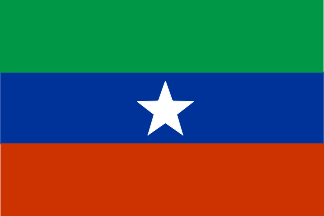 image by
Jaume Ollé, 02 October 2014
image by
Jaume Ollé, 02 October 2014The state of Benaadir was created on 01 July 2011. Its flag comprises horizontal stripes of yellow, light green and light blue, with a white triangle at hoist (1/4 of the length of the flag). In the center of the flag is a white five pointed star on the light blue stripe.
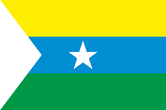 image by Peter Hans van den Muijzenberg, 17 April 2015
A rival Banadir State (with a single “a”) or Banadir Land,
was established in Nairobi in December 2011. Its flag is reported to be three horizontal stripes of
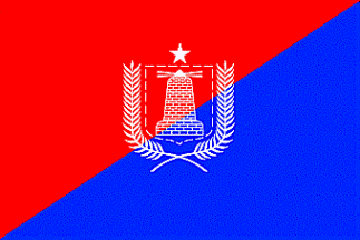
green, white and light blue. A photo shows the arms of state as having a
shield, divided diagonally (red on the left of the observer and blue in the right)
and in center a maroon lighthouse. Above the shield is a blue five pointed star.
The shield is bordered in both sides by a crossed laurel branches and below is a
ribbon with the inscription "Banaadir Land". Near the shield are two
Somali
flags.
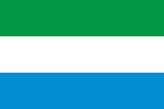 image by Peter Hans van den Muijzenberg, 17 April 2015
Other reports suggest the following flags for Benaadir State:
1) A White flag with the same arms in the center (but the inscription in the
ribbon is "Banadir State" instead "Banaadir Land");
2) A horizontally divided flag of blue over red, with the same arms in the center. The ribbon here is not visible, but the star above the shield is white.
Jaume Ollé, 02 October 2014
The region around the capital City of Mogadishu is called the Region of Benadir (Gobolka Banaadir).
a.gif) images by Valentin Poposki, 27 Aug 2020
images by Valentin Poposki, 27 Aug 2020
An example of the flag mentioned above that is divided diagonally red over
blue with an outline of the Arms in white in the centre is shown above on the
left. A colour illustration of the Arms is shown on the right.
Valentin Poposki, 27 Aug 2020
The administrative/territorial sub-divisions within Benaadir into 17 Districts (Degmada) are as follows:
1. Boondheere
2. Cabdicasiis
3. Dayniile
4. Dharkeenleey
5. Hawlwadaag
6. Heliwaa
7. Hodan
8. Kaaraan
9. Kaxda
10. Shangaani
11. Shibis
12. Waaberi
13. Wadajir
14. Warta Nabadda
15. Xamarjajab
16. Xamarweyne
17. Yaaqshiid

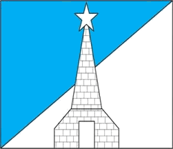
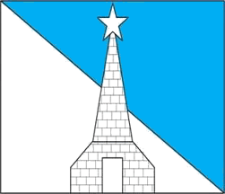 images sent by
Valentin Poposki, 27 Aug 2020 and 13 June 2021
The flag of the District of Boondheere is divided
diagonally light blue over white with the district emblem in the centre.
Valentin Poposki, 27 Aug 2020
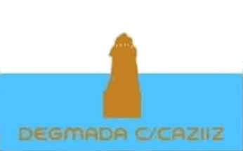 image sent by
Valentin Poposki, 13 June 2021
The flag of District of Cabdicasiis is a horizontal bi-colour of white over
light blue with the distrct emblem in gold in the centre. The name of the
district is printed in gold on the blue stripe.
Valentin Poposki, 13 June 2021

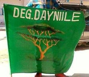 images sent by
Valentin Poposki, 27 Aug 2020
The flag of the District of Daynile (Degmada Dayniile) is
green with the district emblem in the centre and the inscription "DEG. DAYNIILE"
above it.
Valentin Poposki, 27 Aug 2020
Mogadishu, the Somali capital city, is now incorporated into Benadir.
The central and original district of Mogadishu is Hamar Weyne (Xamarweyne), so
logically the city may have the same flag as Benadir.
Jean-Marc Merklin, 28 Aug 2020
 image by Peter Hans van den Muijzenberg, 17 April 2015
Banaadir-Shabelle State was created in Mogadiscio March 2012 claiming
Banaadir,
Lower Shabelle and Middle Shabelle, but it was quickly suppressed. Its flag was horizontal
stripes of green, white, green (in proportion of 2:1:2) with a light blue triangle at hoist
containing a white five pointed star. A photo shows a long flag (1:3 or so), but probably
the usual proportion is 2:3.
Islamists in Banadir fly a green flag with Arabic inscriptions. Two
photos show a green flag with a white stripe perhaps diagonal with a blue element in
the centre.
Jaume Ollé, 02 October 2014
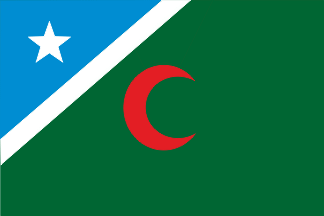 image by
Jaume Ollé, 03 October 2014
image by
Jaume Ollé, 03 October 2014Ceelbaraf state was proclaimed at north of Mogadishu in the city of al Baraf.
The only image of the flag of this self-proclaimed state is shown on
Somalia
Online.
Jaume Ollé, 03 October 2014
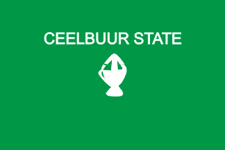 image by Peter Hans van den
Muijzenberg, 19 April 2015
 image by
Peter Hans van den Muijzenberg, 19 April 2015
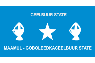 image by Peter Hans van den
Muijzenberg, 19 April 2015
image by Peter Hans van den
Muijzenberg, 19 April 2015The following link
http://www.afnugaal.com/ktmllite/images/uploads/AA%20darwiishland%20flag.JPG
shows an image named the "Darwishland flag". It looks
like a Somali flag with a horse head and the words "Darwishland of
Somalia" added.
The image does not give the proof that Darwiishland /Northland state of Somalia
actually uses this as a flag but I think it was worth being
reported.
Olivier Touzeau, 02 Aug 2008
 image by
Jaume Ollé, 04 October 2014
 image by
Jaume Ollé, 04 October 2014
 Cai Zhenyuan and resized by Eugene Ipavec, 06 Dec
2010
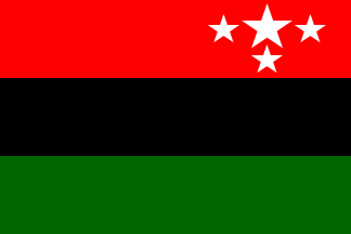
State Flag of the Federated
Hinterland State is shown at http://www.maayland.com/hinterland.htm
and is described as follows: Cai Zhenyuan, 05 Dec 2010
A horizontally divided green-light blue-red flag with five white stars in line on
the blue stripe is shown at
http://www.allgedo.com/Tempe/fegradda%20daahir%20faarax%20ee%20calanka%20mgg%20n\ews.htm
as the flag of Gedoland - an autonomous area within Somalia.
The
State Flag shall have a rectangular shape with three equal horizontal stripes. Green indicates the fertile nature of the territory and
is the bottom stripe; Red indicates the bloodshed and is the top stripe. The Black
stripe indicates that Federated Hinterland is African State
within the Somali Federal Republic
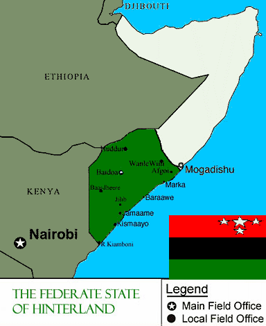
A map of the area showing an image of the flag has been provided.
Rob Raeside, 06 Dec 2010
Gedoland
Olivier Touzeau, 02 Aug 2008
Hiiraan State
It was reported by
HOL that on 13 July
2010 a preliminary conference was organized and sponsored by the Hawadle Clan of
Hiiraan to formally pave the way for reconciliation and to establish a local
administration in the Hiiraan region of Somalia was held in the conference hall
of Andolus Hotel in Eastleigh, Nairobi. A flag for Hiiraan, as shown,
above was displayed at the conference.
Cai Zhenyuan, 13 Mar 2011
 Image by Cai Zhenyuan, 03 May 2012
Khaatumo was announced in January 2012 after a meeting in Taleh town of Sool
and it comprises the Sool, Sanaag and Eyn regions. Khatumo was established
during a conference known as Khatumo2 and supports the Transitional Federal
Government (TFG) rather than Somaliland. The
Dhulbahante clan, a sub clan of Darod clan, is dominant in the regions of Sool,
Sanag and Eyn and has maintains the SSC militia fighters who fought against
Somaliland in Buuhoodle. Major politicians including Ali Khalif Galeyr, a former
Somali prime minister and lecturer at US universities, backed the conference.
The Khatumo state of Somalia will have three presidents, rotating on a six month
basis, and a Supreme Council comprising of three members, and a cabinet of six
members. The three routine presidents are: Ahmed Elmi Osman (Amed Karash),
Mohmaed Yusuf Jama (Indhasheeel) and Nur Elmi (Biindhe). In March of this year,
the TFG officially recognized Khatumo. In March 2012, the TFG recognized the
state, but rescinded this few days a later.
Cai Zhenyuan,16 July 2013
Khaatumo State is a newly formed semi-autonomous state located in north eastern Somalia. It was formed after a conference held in the Taleh district of Sool region in December 2011. The conference was attended by representatives from Sool, Sanaag and Cayn regions.
Based on a photograph on
flickr, the state flag
has a dark blue background with a large white five-pointed star in the hoist
half and a horse in the fly half, also in white. The name of the state (in
English) is written at the top of the flag in white.
Cai Zhenyuan, 03 May 2012
 Image by
Cai Zhenyuan, 27 May 2013
According to this
source, Khaatumo has a new flag which is blue with a white five-pointed star
in the centre. Near the hoist, to the left of the star, is a jumping white
horse. No further information is provided.
Cai Zhenyuan, 27 May 2013
An image of the flag of Maayland / Southern Somali Union is shown at http://maayland.com/. This flag has already been reported as the flag of South-West Somalia.
Olivier Touzeau, 02 Aug 2008
A map of the area showing an image of the flag has been provided. Galgaduud State Geel State claims to control of part of Jubaland, Inner Shabelle (Baardhere)
and Inner Hiraan, but probably its control is in fact very limited. The upper first two-thirds of its flag has a white background, with a light
blue five pointed star in the canton and a black camel (facing towards the fly)
in the centre. The lower third is a light blue horizontal stripe.
The fly (one third the length of the flag) comprises a narrow green vertical
stripe and a thicker orange/light brown coloured stripe. Greenland state was proclaimed Nairobi on 21
November 2010. The only evidence of a flag is unclear, but appears to show
a flag with a plain green or turquoise background on which is a black inscription
- Greenland State of Jubba. Hosted by: Fanshop-Online.de und Handy-Shop.de 
Rob Raeside, 06 Dec 2010
Gaarodi
Gaarodi state was proclaimed in February 2012.
It uses the Somali flag. In the upper part is a longer white rectangle
within which is the underlined blue inscription “GAARODI STATE OF SOMALIA”.
Jaume Ollé, 04 October 2014
Gal-Hiiraan and Haradhere State
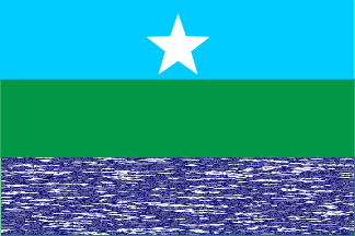 image by
Jaume Ollé, 04 October 2014
image by
Jaume Ollé, 04 October 2014This state was proclaimed on 23 September 2010. The main city is Haradhere, a pirate
stronghold, which is ruled by the Ayr clan.
The flag is confirmed by a photo and has three equal horizontal stripes of light blue,
green, and dark blue. The latter shading simulating the waters of the sea. In
Flaggenkourier (No. 39, June 2014),
the lower stripe is simplified to a plain dark blue.
Jaume Ollé, 04 October 2014
 image by
Željko Heimer, 20 Jan 2003
Galgaduud State was created in April 2011 in Dubai. It claims all Galgaduud
together with the
zones governed by the self proclaimed states of Galmudug, Himav
and Heb, Mareeg,
Ceelbuur, Gal-Hiraan and Haradhere and
Somali Central State.
The flag in use is the Somali national flag which is
confirmed by several photos.
Jaume Ollé, 04 October 2014
Ganaane (Waajid)
Ganaane
State was proclaimed on 12 January 2012 in the Wajid district in the south-west of
Somalia.
The flag, confirmed in a photograph has horizontal stripes of white, light blue, red with a
triangle light blue at hoist bearing a white star.
Jaume Ollé, 08 October 2014
Gedoland
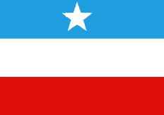 image by Valentin Poposki,
04 Jan 2023
image by Valentin Poposki,
04 Jan 2023It seems that on 28 August
2022 the Region of Gedo, in Jubaland State, proclaimed
itself a state. The political situation is not clear but the region has a new
flag as shown above which can be seen
here.
Valentin Poposki, 04 Jan 2023 A
horizontally
divided green-light blue-red flag with five white stars in line on the blue
stripe is shown at
here as the flag of Gedoland, an autonomous area within
Somalia.
Olivier Touzeau, 02 Aug 2008
Gedo State was proclaimed in 2006. The flag has horizontal stripes of
green, light blue and red; with five white stars in the centre of the blue
stripe.
Jaume Ollé, 09 October 2014
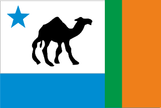 image by
Jaume Ollé, 09 October 2014
Jaume Ollé, 09 October 2014
Jaume Ollé, 09 October 2014
Tipp: Apple iPhone 14 im Shop